
aceofspadeshq at gee mail.com
CBD:
cbd at cutjibnewsletter.com
Buck:
buck.throckmorton at protonmail.com
joe mannix:
mannix2024 at proton.me
MisHum:
petmorons at gee mail.com
J.J. Sefton:
sefton at cutjibnewsletter.com
Hobby Thread - March 21, 2026 [TRex]
![IMG_20260317_170550[12].jpg](http://ace.mu.nu/archives/IMG_20260317_170550[12].jpg)
Welcome hobbyists! Pull up a chair and sit a spell with the Horde in this little corner of the interweb. This is the mighty, mighty officially sanctioned Ace of Spades Hobby Thread. When you follow the long and windy road, you end up with maps as a theme for this Hobby Thread.
[Top photo: Lupine Lane, 20x30 acrylic, Misanthropic Humanitarian]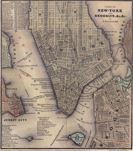
This is the most accurate depiction of the South that I've seen. I'm in the orange area.
— Blonde of War (JJ) (@BlondeOfWar) March 13, 2026
Is there a better map breakout? pic.twitter.com/quOWEIGGiM

10 Things Every Map Collector Should Know
Words of wisdom:
"Because despite all our troubles, when things are grim out in that wide round world of ours, that's when it's really important to have a good hobby." Posted by: tankascribe at June 22, 2024 07:41 PM (HWxAD).
If you have trouble finding something in the content or comments that resonates with you, contribute your own. Send thoughts, suggestions and photos of your hobbying to moronhobbies at protonmail dot com. Do mighty things but don't run with scissors.
Comments
(Jump to bottom of comments)Posted by: Skip at March 21, 2026 05:31 PM (Ia/+0)
Posted by: Diogenes at March 21, 2026 05:34 PM (2WIwB)
Big problem is what was two hundreds of years ago may be totally changed in a map of today.
Posted by: Skip at March 21, 2026 05:34 PM (Ia/+0)
Posted by: JTB at March 21, 2026 05:38 PM (yTvNw)
Posted by: Castle Guy at March 21, 2026 05:39 PM (Lhaco)
Posted by: Rev. Wishbone at March 21, 2026 05:40 PM (LkMIg)
Posted by: Chairman LMAO at March 21, 2026 05:40 PM (cWLG3)
Posted by: All Hail Eris, She-Wolf of the 'Ettes 'Ettes. at March 21, 2026 05:40 PM (kpS4V)
Posted by: Skip at March 21, 2026 05:40 PM (Ia/+0)
I've no idea about how to research them. And my brother is literally 80% blind and I'm not sure he knows what does or doesn't have.
Posted by: Diogenes at March 21, 2026 05:42 PM (2WIwB)
Posted by: Chairman LMAO at March 21, 2026 05:43 PM (cWLG3)
Posted by: Eromero at March 21, 2026 05:45 PM (LHPAg)
I've no idea about how to research them. And my brother is literally 80% blind and I'm not sure he knows what does or doesn't have.
Posted by: Diogenes at March 21, 2026 05:42 PM (2WIwB)
---
Take a look at "penny values" at coinvalues.com. You should be able.to ID what you have and get an idea of its value.
https://coinvalues.com/
Posted by: Chairman LMAO at March 21, 2026 05:48 PM (cWLG3)
Posted by: All Hail Eris, She-Wolf of the 'Ettes 'Ettes. at March 21, 2026 05:48 PM (kpS4V)
You can get them all at https://skyvector.com
Posted by: "Perfessor" Squirrel at March 21, 2026 05:52 PM (ESVrU)
Posted by: All Hail Eris, She-Wolf of the 'Ettes 'Ettes. at March 21, 2026 05:53 PM (kpS4V)
Selling a highly accurate map to an enemy nation or competing business venture could get you killed.
Posted by: "Perfessor" Squirrel at March 21, 2026 05:54 PM (ESVrU)
Plus you can't zoom it *out* to see the surrounding area, which is important. Give me the Road Atlas from Walmart. I still have one from 2016 and it serves me well.
For closeups, such as Interstate exits to my hotel, I will call it up on the computer and try to print out the screen, then stash it in my trip folder.
Posted by: Wolfus Aurelius, Dreaming of Elsewhere at March 21, 2026 05:55 PM (wzUl9)
I've no idea about how to research them. And my brother is literally 80% blind and I'm not sure he knows what does or doesn't have.
Posted by: Diogenes at March 21, 2026 05:42 PM (2WIwB)
I used to collect as a kid. My recollection is there are one, maybe two, truly valuable old pennies. The one I remember was the "1909 S VDB." I think maybe the other one was a "small date" something. Of course, some others may have become valuable since then. I had no valuable ones, but I thought the steel (?) ones made during the war were really cool.
Posted by: Splunge at March 21, 2026 05:56 PM (KEowH)
https://is.gd/uVvd2v
Posted by: CharlieBrown'sDildo at March 21, 2026 05:57 PM (n9ltV)
Most of the courses involve learning "geodesy" -- the science of measuring and representing the geometry, gravity, and spatial orientation of the Earth.
There's A LOT of cool stuff that science can do now to generate incredibly precise maps of the Earth focusing on any detail you can imagine.
Posted by: "Perfessor" Squirrel at March 21, 2026 05:57 PM (ESVrU)
A buddy and I were freshmen at IU. Known each other since Boy Scouts. This is 1993. IU has/had a massive library five floors in the undergrad tower and 14 floors in the research tower. We were still wide eyed and seeing the shit that the university life had aside from alcohol and boobs.
Some tells me one day: hey, someone told me about where we could find some maps in the library. Its way up in the stacks. Me: really? Could be cool.
So we head up to the 13th floor(iirc) of the research collection. Each of these floors is just rows and rows of bookshelves (some study carols around the perimeter.) We head back (i could probably still find it if they have not moved everything) and we find the section. Books and books and books of maps (atlases.) So we start looking and amongst these we found these flat boxes.
Tbc
Posted by: Aetius451AD work phone at March 21, 2026 05:57 PM (zZu0s)
Posted by: BarelyScaryMary at March 21, 2026 05:58 PM (w5FC4)
Posted by: BarelyScaryMary at March 21, 2026 05:58 PM (w5FC4)
---
When I was a kid I decorated my bedroom with the fold-out map posters from National Geographic magazine. They were really cool.
Posted by: "Perfessor" Squirrel at March 21, 2026 05:59 PM (ESVrU)
Posted by: Skip at March 21, 2026 06:00 PM (Ia/+0)
A local framing shop has framed prints of vintage (meaning, ca. 1840s or 1910) maps.
Posted by: Wolfus Aurelius, Dreaming of Elsewhere at March 21, 2026 06:02 PM (wzUl9)
Opened one of them and it was stacks of sheets of paper. Map plates meant to be put together to make a much larger map. Memory says they (the plates) were larger than 11x17, but that would make the most sense from a sizing perspective. We found one we could tell was a world map that had like 16 plates, but another that was far more detailed and was what we thought was a map of western Europe. I wanna say it was like 32 plates. Very fine detail. Hell, it might have been just Germany.
So we are looking at these and we both have the same thought:
Andy: take them to the copier downstairs?
Me: I don't think they have paper this size in those copiers.
Andy: Kinkos or Staples?
Me: we'd have to smuggle them out using those architect tube things...
Posted by: Aetius451AD work phone at March 21, 2026 06:03 PM (zZu0s)
10 Does anyone know anything about coin collecting? My brother believes he has several very valuable old pennies. Specifically wheat pennies.
I've no idea about how to research them. And my brother is literally 80% blind and I'm not sure he knows what does or doesn't have.
Posted by: Diogenes at March 21, 2026 05:42 PM (2WIwB)
Posted by: Are you sure about this sir? at March 21, 2026 06:03 PM (U/7CP)
Posted by: Skip at March 21, 2026 06:03 PM (Ia/+0)
Posted by: Cicero (@cicero43) at March 21, 2026 06:04 PM (wTn/p)
Posted by: BarelyScaryMary at March 21, 2026 06:05 PM (w5FC4)
So we left after repacking the maps. Visions of wall sized maps on our dorm rooms to plan our heist.
The sad part is we never did it (aforementioned alcohol and boobs) but I still am curious about those maps. They were very cool.
Posted by: Aetius451AD work phone at March 21, 2026 06:06 PM (zZu0s)
Best maps ever were from The Alexandria Drafting Company. Still have one of their mid Atlantic wall maps...
Posted by: man at March 21, 2026 06:06 PM (cGjQu)
-----------
No, you can't go back to Constantinople
Been a long time gone, Constantinople
Why did Constantinople get the works?
That's nobody's business but the Turks
Posted by: Cicero (@cicero43) at March 21, 2026 06:08 PM (wTn/p)
Posted by: Hokey Pokey at March 21, 2026 06:08 PM (YlWIZ)
Which I already knew. Heart of Dixie. Smack dab in the middle of MS.
When I moved West in college I had to learn how to say my one syllable name fast like I was chy knee... in one syllable... vs two. Basically I stunned people that I had all of my teeth and was fairly intelligent.
One girl at a party a year later was looking at me and said I was "exotic." I have been called a whole lot of things in my life, but that was the only time for that one. She might have been stoned.
It's too dang hot to talk fast there.
Posted by: ChristyBlinkyTheGreat at March 21, 2026 06:10 PM (WONhk)
Posted by: JTB at March 21, 2026 06:11 PM (yTvNw)
Posted by: Eromero
>I made one last night that was spectacular. The art of the cheeseburger is the stack. What is the optimum top to bottom order of the toppings and condiments? This is very controversial and I still believe the definitive solution is up for debate.
Posted by: Rev. Wishbone at March 21, 2026 06:15 PM (LkMIg)
---------
Heh. How you doin'?
Posted by: Cicero (@cicero43) at March 21, 2026 06:16 PM (wTn/p)
Posted by: Mrs. Leggy at March 21, 2026 06:16 PM (dyL4B)
Posted by: BarelyScaryMary at March 21, 2026 06:17 PM (w5FC4)
Posted by: JTB at March 21, 2026 06:18 PM (yTvNw)
Posted by: Skip at March 21, 2026 06:18 PM (Ia/+0)
Posted by: man at March 21, 2026 06:18 PM (cGjQu)
--------
Umm, yes. I mean NO!
Posted by: Cicero (@cicero43) at March 21, 2026 06:20 PM (wTn/p)
Posted by: banana Dream at March 21, 2026 06:20 PM (3uBP9)
Barely Scary Mary...I love Steve Winwood. He sings in the choir at his church in England.
My favorite of all time song/video of his, when I feel like dancing, is Higher Love:
https://tinyurl.com/35upbnkd
Posted by: ChristyBlinkyTheGreat at March 21, 2026 06:21 PM (WONhk)
Really nice bluebonnets this year...
Posted by: man
That's a nice painting.
And the name checks out; it doglegs left into the distance.
Posted by: mikeski at March 21, 2026 06:21 PM (VHUov)
Posted by: mrp at March 21, 2026 06:21 PM (7s6/v)
Agree that paper maps are the best. Everyone should be able to read and navigate with a paper map and compass
IMHO.
Posted by: RS at March 21, 2026 06:22 PM (SuU/K)
Posted by: ChristyBlinkyTheGreat
So the rest of the choir can brag "I sang backup for Steve Winwood."
Posted by: mikeski at March 21, 2026 06:22 PM (VHUov)
Posted by: mrp at March 21, 2026 06:23 PM (7s6/v)
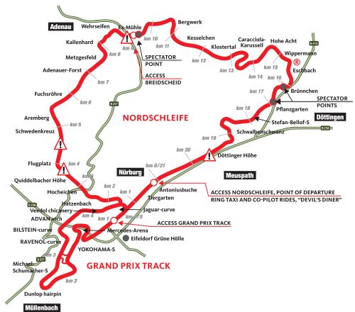
Now it's "WHATS YOUR VEHICLES NURBURGRING TIME" dominates any conversation of a vehicles prowess.
Posted by: JROD at March 21, 2026 06:24 PM (IlL6s)
Agree that paper maps are the best. Everyone should be able to read and navigate with a paper map and compass
IMHO.
Posted by: RS at March 21, 2026 06:22 PM (SuU/K)
------------
Go parallel rules or go home
Posted by: Cicero (@cicero43) at March 21, 2026 06:24 PM (wTn/p)
Posted by: The Grateful - Acta Non Verba at March 21, 2026 06:24 PM (IQ6Gq)
I'll just say that some of my experiences with GPS are part of the reason I always have paper maps in the car. (Topic related.) Our GPS is several years out of date. Maybe they have improved recently but the one we have can get kinda uppity and insistent if we didn't follow their direction.
Posted by: JTB at March 21, 2026 06:24 PM (yTvNw)
I think I still have a copy of that around here somewhere.
Posted by: "Perfessor" Squirrel at March 21, 2026 06:25 PM (ESVrU)
It kept the rules-lawyers from Wesley Crushering my interpretation of things in Greyhawk or the Forgotten Realms.
Posted by: mikeski at March 21, 2026 06:25 PM (VHUov)
Posted by: The Grateful - Acta Non Verba at March 21, 2026 06:25 PM (IQ6Gq)
--------------
Pfft.
The Isle of Man TT race course, known as the Snaefell Mountain Course, is 37.73 miles (60.72 kilometers) long.
Posted by: Mike Hammer, etc., etc. at March 21, 2026 06:26 PM (XeU6L)
Posted by: Cicero (@cicero43) at March 21, 2026 06:26 PM (wTn/p)
Some amazing technology from the early 1900's.
Some amazing technology from the early 2000's.
Posted by: Martini Farmer at March 21, 2026 06:27 PM (AkEZC)
Posted by: banana Dream at March 21, 2026 06:27 PM (3uBP9)
Posted by: Skip at March 21, 2026 06:27 PM (Ia/+0)
Posted by: The Grateful
------
The fellow is talented...and has an eye for the things around us.
Posted by: Mike Hammer, etc., etc. at March 21, 2026 06:28 PM (XeU6L)
Posted by: mrp at March 21, 2026 06:21 PM (7s6/v)
How about as typographical map of iran? Sans Sharifs.
Posted by: Alberta Oil Peon at March 21, 2026 06:28 PM (8zz6B)
Posted by: Skip at March 21, 2026 06:29 PM (Ia/+0)
Posted by: Bob, at the NSA at March 21, 2026 06:30 PM (XeU6L)
We also had a wonderful binder of Texas counties in large scale, with all the various grades of roads, for state travel.
I will take a map any day over GPS.
Posted by: sal at March 21, 2026 06:30 PM (f+FmA)
--------------
Pfft.
The Isle of Man TT race course, known as the Snaefell Mountain Course, is 37.73 miles (60.72 kilometers) long.
Posted by: Mike Hammer, etc., etc. at March 21, 2026 06:26 PM (XeU6L)
-------
Pfft
The Large Hadron Collider encompasses 13 towns in France and Switzerland.
Posted by: Cicero (@cicero43) at March 21, 2026 06:30 PM (wTn/p)
Posted by: banana Dream at March 21, 2026 06:31 PM (3uBP9)
The Large Hadron Collider encompasses 13 towns in France and Switzerland.
Posted by: Cicero (@cicero43) at March 21, 2026 06:30 PM (wTn/p)
----
And the particles on that "race course" are traveling around 99.9% of the speed of light...
Posted by: "Perfessor" Squirrel at March 21, 2026 06:32 PM (ESVrU)
Posted by: sal at March 21, 2026 06:30 PM (f+FmA)
Richard Gere is a great fan of Gerbil Positioning Systems.
Posted by: Alberta Oil Peon at March 21, 2026 06:32 PM (8zz6B)
Posted by: vmom deport deport deport at March 21, 2026 06:32 PM (tcsrY)
In spite of my navigational deficiencies, I definitely enjoy both paper and online maps. I don't do as many road trips as I used to, but I like to use both Google maps and a road atlas for planning.
Beautiful painting, Mis Hum.
Posted by: screaming in digital at March 21, 2026 06:33 PM (MSrAy)
Regarding maps, you reminded me of an Ancient Aliens episode where they discussed maps of Antarctica from the 1500's!!
This was from a site called seekernotes...
"Ancient Antarctica on Medieval Maps
You might be surprised to learn that Antarctica appears on maps created centuries before its official discovery in 1820. The Pinkerton World Map from 1813-1818 shows just a blank space where Antarctica should be, yet much older maps seem to know exactly where it is.
The Walle Wooler world map from 1530 clearly shows Antarctica positioned south of both South America and Africa. The mapmakers called it the “Southern Land,” and interestingly, they depicted it as much larger than it appears today. This size difference makes sense because during the Ice Age, Antarctica was indeed much bigger before ice sheets covered so much of the continent.
The mystery deepens when you consider that these 1500s maps were based on even older source materials."
Posted by: Stateless at March 21, 2026 06:34 PM (Sco7b)
Posted by: Notsothoreau at March 21, 2026 06:35 PM (gQ15S)
Now, after having compasses on the Regal, BMW, and LaCrosse, it would be hard to do without it. It's saved me many a time on trips -- even around town.
Posted by: Wolfus Aurelius, Dreaming of Elsewhere at March 21, 2026 06:35 PM (wzUl9)
"Ancient Antarctica on Medieval Maps
---------
*Here There Be Penguins*
Posted by: Cicero (@cicero43) at March 21, 2026 06:35 PM (wTn/p)
Posted by: JTB at March 21, 2026 06:35 PM (yTvNw)
But damned if I remember the publisher!
Posted by: CharlieBrown'sDildo at March 21, 2026 06:35 PM (n9ltV)
Posted by: banana Dream at March 21, 2026 06:35 PM (3uBP9)
Posted by: The Grateful - Acta Non Verba at March 21, 2026 06:36 PM (IQ6Gq)
Posted by: CharlieBrown'sDildo at March 21, 2026 06:35 PM (n9ltV)
---------
The Thomas Guide.
A CA classic.
Posted by: Cicero (@cicero43) at March 21, 2026 06:36 PM (wTn/p)
But damned if I remember the publisher!
Posted by: CharlieBrown'sDildo at March 21, 2026 06:35 PM
***
Thomas Guide!
Posted by: TRex - directional dino at March 21, 2026 06:36 PM (IQ6Gq)
Posted by: JTB at March 21, 2026 06:38 PM (yTvNw)
Posted by: BeckoningChasm at March 21, 2026 06:38 PM (CHHv1)
Posted by: banana Dream at March 21, 2026 06:39 PM (3uBP9)
Posted by: Mike Hammer, etc., etc. at March 21, 2026 06:39 PM (XeU6L)
Up above 3, there are a bunch of Tree names and there are a couple of sections with named streets, but that's about it.
Posted by: sal at March 21, 2026 06:40 PM (f+FmA)
The mystery deepens when you consider that these 1500s maps were based on even older source materials."
Posted by: Stateless
***
One of the YT videos that was considered for content was focused on how maps were drawn in olden and ancient times. Fascinating scientific knowledge and problem solving. The video itself wasn't great and didn't make the content cut (yes, we have standards here).
Posted by: TRex - directional dino at March 21, 2026 06:40 PM (IQ6Gq)
Posted by: Cicero (@cicero43) at March 21, 2026 06:40 PM (wTn/p)
Posted by: Mike Hammer, etc., etc. at March 21, 2026 06:41 PM (XeU6L)
Posted by: PabloD at March 21, 2026 06:42 PM (uqy/m)
Thanxs.
Posted by: Diogenes at March 21, 2026 06:43 PM (2WIwB)
In the end, I found D&D to be tedious.
Posted by: Pug Mahon, Rock 'n' Roll Martian at March 21, 2026 06:44 PM (0aYVJ)
----
Here, there is a single numbered street, 20th Street. It is the only numbered street in the town.
Posted by: Mike Hammer, etc., etc. at March 21, 2026 06:45 PM (XeU6L)
Posted by: tintex at March 21, 2026 06:45 PM (SQDL/)
Posted by: Stateless
***
One of the YT videos that was considered for content was focused on how maps were drawn in olden and ancient times. Fascinating scientific knowledge and problem solving. The video itself wasn't great and didn't make the content cut (yes, we have standards here).
Posted by: TRex - directional dino at March 21, 2026 06:40 PM (IQ6Gq)
One wonders if perhaps the mysterious Sea People were in fact really sea people, and had originated some place far beyond the Pillars of Hercules, maybe even North America, and had sailed and mapped most of the world's oceans.
Posted by: Alberta Oil Peon at March 21, 2026 06:45 PM (8zz6B)
Posted by: TRex - directional dino
>An indispensable resource, especially if your employer required you to travel. I had one that took me from Valencia to San Clemente.
Posted by: Rev. Wishbone at March 21, 2026 06:46 PM (LkMIg)
It shows. A lot of work obviously goes into this thread. Well, pretty much all of the threads..... All of you do great work and it's appreciated.
Posted by: The Grateful - Acta Non Verba at March 21, 2026 06:36 PM (IQ6Gq)
Thank you so much. Things are getting better and better and I appreciate the prayers.
Oh, last thing on maps, I sent over to my friends kids, not only graph paper but D&D HEXAGON MAP PAPER. I'm not sure how easy that is to find anymore...
Posted by: Stateless at March 21, 2026 06:46 PM (Sco7b)
Another was discovering that from battle maps Confederate troops marched through what is now our backyard on the way to First Battle of Bull Run.
Posted by: JTB at March 21, 2026 06:46 PM (yTvNw)
That's good news. Keep us informed. Prayer thread is a great place....
Posted by: Stateless at March 21, 2026 06:47 PM (Sco7b)
Posted by: Michael Stipe at March 21, 2026 06:49 PM (PCHuB)
I am easing back into writing without using voice-to-text. I really am not much of a verbal storyteller.
Posted by: NaughtyPine at March 21, 2026 06:49 PM (iv237)
Posted by: JTB
**********
That is pretty cool....
Posted by: The Grateful - Acta Non Verba at March 21, 2026 06:49 PM (IQ6Gq)
Almost necessary for some games.
Back in the day I'd have to do my own mapping using graph paper for games like Bard's Tale or Might and Magic.
Posted by: "Perfessor" Squirrel at March 21, 2026 06:52 PM (ESVrU)
Posted by: Aetius451AD work phone at March 21, 2026 06:53 PM (zZu0s)
I'm always very disoriented coming out of a subway or metro station in an unfamiliar city. I've taken to setting the GPS to my destination and just starting out in any direction. If it starts rerouting me, or the time to destination goes up not down, I turn around...
Posted by: screaming in digital at March 21, 2026 06:54 PM (MSrAy)
Posted by: Skip at March 21, 2026 06:54 PM (Ia/+0)
Posted by: JackStraw at March 21, 2026 06:54 PM (viF8m)
Posted by: BarelyScaryMary at March 21, 2026 06:54 PM (w5FC4)
Here, there is a single numbered street, 20th Street. It is the only numbered street in the town.
Posted by: Mike Hammer
How did it get its name?
Posted by: Bertram Cabot, Jr. at March 21, 2026 06:55 PM (Cqx++)
Posted by: fd at March 21, 2026 06:55 PM (vFG9F)
Posted by: Rev. Wishbone at March 21, 2026 05:40 PM (LkMIg)
I can help you with that.
Posted by: Grok AI at March 21, 2026 06:55 PM (PCHuB)
He also found that the state trust land encroached on our property with their shoddy fence by 15 ft across the entire back. We're not going to make a big deal about it because, we don't want them "discovering" some artifacts or some other tribal BS any where near the property line. We do have some petroglyphs on the ranch.
Posted by: Maj. Healey at March 21, 2026 06:57 PM (abIsI)
See if this goes to the drawing, it's from Gov records
Posted by: Skip at March 21, 2026 06:57 PM (Ia/+0)
Posted by: Joe Kidd at March 21, 2026 06:57 PM (nbLIj)
Posted by: Maj. Healey at March 21, 2026 07:02 PM (abIsI)
/huntsville
Posted by: Itinerant Alley Butcher at March 21, 2026 07:02 PM (/lPRQ)
See if this goes to the drawing, it's from Gov records
Posted by: Skip at March 21, 2026 06:57 PM
***
It works. Quite something to see. Thanks much for sharing.
Posted by: TRex - saving private dino at March 21, 2026 07:02 PM (IQ6Gq)
Posted by: BarelyScaryMary at March 21, 2026 07:03 PM (w5FC4)
Posted by: JTB at March 21, 2026 07:04 PM (yTvNw)
Posted by: Berserker-Dragonheads Division at March 21, 2026 07:04 PM (snZF9)
Posted by: TRex - over the hills and though the woods dino at March 21, 2026 07:04 PM (IQ6Gq)
For serious map lovers, my alma mater (and former employer) The University of Texas has an enormous collection of maps of all kinds available online.
https://maps.lib.utexas.edu/maps/
Posted by: Art Rondelet of Malmsey at March 21, 2026 07:05 PM (FEVMW)
Posted by: Skip at March 21, 2026 07:06 PM (Ia/+0)
Posted by: Maj. Healey at March 21, 2026 07:06 PM (abIsI)
Posted by: JTB at March 21, 2026 07:07 PM (yTvNw)
Posted by: JTB
We were detail oriented.
Posted by: Lewis & Clark at March 21, 2026 07:08 PM (abIsI)
Now I gotta go fix some sweet tea.
Posted by: Quarter Twenty at March 21, 2026 07:09 PM (2Ez/1)
Posted by: BarelyScaryMary at March 21, 2026 07:13 PM (w5FC4)
Posted by: JTB at March 21, 2026 07:07 PM (yTvNw)
yeah, like some of the ancient maps out there that show things they shouldn't have known.
Posted by: Berserker-Dragonheads Division at March 21, 2026 07:14 PM (snZF9)
Posted by: Rev. Wishbone at March 21, 2026 07:15 PM (LkMIg)
Posted by: Braenyard - some Absent Friends are more equal than others _ at March 21, 2026 07:15 PM (MF/Oh)
Posted by: nurse ratched at March 21, 2026 07:15 PM (A5RD0)
Posted by: Berserker-Dragonheads Division at
Aliens. Obviously.
Posted by: Piper at March 21, 2026 07:16 PM (p4NUW)
Posted by: Piper at March 21, 2026 07:18 PM (p4NUW)
Learned aeronautical sectional charts in a high school class. I bought two covering most of Florida where I lived at the time. Remember showing them to my dad and him laughing and shaking his head saying I could think of the most ridiculous things to spend money on....LOL!
Posted by: Anonymous Rogue in Kalifornistan (ARiK) at March 21, 2026 07:19 PM (VS/AS)
The last day of third grade, we each got an aerial navigation map of Central Europe. All but the southern extremity of the FRG is depicted. It has a good chunk of the UK and the southern extremity of Sweden. And...a good portion of Eastern Europe. It depicts the aerial pathways to Berlin, and has warnings posted in various spots warning that flying is restricted and aircraft can and will be fired on without warning. "Consult NOTAMS for the latest information".
We all put the map on our walls at home.
It's fragile now but I still have it, folded up.
Posted by: Cow Demon at March 21, 2026 07:19 PM (hJH5n)
I on the other hand start hyperventilating when I try to read a map.
Fortunately we both liked to ski.
Since I have some sf fantasy mss, my son tells me I have to include maps, so I'm very grateful for this thread, TRex.
Any listing of good books on fantasy maps would be appreciated. I have a lot to learn.
Posted by: Wenda at March 21, 2026 07:19 PM (q4/FL)
Posted by: Berserker-Dragonheads Division at
Aliens. Obviously.
Posted by: Piper at March 21, 2026 07:16 PM (p4NUW)
***
Here there be Monsters!
Posted by: Diogenes at March 21, 2026 07:21 PM (2WIwB)
Posted by: Cow Demon at March 21, 2026 07:21 PM (hJH5n)
I am functionally retarded navigation wise. I don't mean that mockingly, I believe there is something seriously wrong with my spatial sense. It is practically not there. I have gotten lost in a closet many times. Walked in, then wasn't sure how to get out. But I have systems like, spinning around until an exit appears. My car system is to drive in increasingly large spirals, like right turns only until something comes up. It is actually very hard to deal with and phone guidance helps a lot.
I used to print maps and had a car full of maps a long time ago.
Posted by: banana Dream at March 21, 2026 07:21 PM (3uBP9)
Posted by: Berserker-Dragonheads Division at
Aliens. Obviously.
Posted by: Piper at March 21, 2026 07:16 PM (p4NUW)
Or some smart unknown ancient civilizations. The Peri Reis map for example, drawn in the 1500's and shows a pre ice covered Antarctica.
Posted by: Berserker-Dragonheads Division at March 21, 2026 07:22 PM (snZF9)
Posted by: JackStraw at March 21, 2026 07:23 PM (viF8m)
Don't forget to stop by Club ONT later.
Posted by: TRex - not all who wander are lost at March 21, 2026 07:24 PM (IQ6Gq)
Posted by: BarelyScaryMary at March 21, 2026 07:25 PM (w5FC4)
Posted by: jayhawkone at March 21, 2026 07:27 PM (ZmtS8)
Posted by: Fritz Geiger at March 21, 2026 07:28 PM (3uc8k)
At the end of the trip, I was given two charts, complete with pencil marks in a heavy cardboard cylinder.
Posted by: nurse ratched at March 21, 2026 07:29 PM (A5RD0)
Posted by: Braenyard - some Absent Friends are more equal than others _ at March 21, 2026 07:30 PM (MF/Oh)
I have never driven the Collider, I don't care what she says.
Too bad there's no more real Bond movies. That would go in.
I was a government map maker once, although I can't do geodesy math. There were a lot of fun cheats for that. My sympathy is, and has always been, with the guys who made up those physical printing plates for 'real' maps. When you suddenly do away with Cesar Chavez Boulevard, just to idly fantasize a case, they have to go all hammer and tongs. In my shop we had chart paper, drawing boards, and for a while, mylar transparencies with rotary erasing machines.
To a developer, the purpose of an address and street name is to sell the lot. He doesn't care about ambulance drivers a bit.
Posted by: Way, Way Downriver at March 21, 2026 07:32 PM (zdLoL)
Imagine getting on a ship in the 1600s and heading out into a largely uncharted ocean that many thought was certain death.
Posted by: JackStraw at March 21, 2026 07:33 PM (viF8m)
Posted by: BarelyScaryMary
Unauthorized trail markers an issue in this area. Some people feel the need to blaze mark trails because they are sure it is the correct route, same with rock cairns. A few hikers have gotten seriously lost by following these markers.
Rock cairns(karens) should only be used for your own backtrack route and should be taken down as you pass them on the way out.
Posted by: Maj. Healey at March 21, 2026 07:33 PM (abIsI)
Posted by: JackStraw
******
The very definition of faith...
Posted by: The Grateful - Acta Non Verba at March 21, 2026 07:35 PM (IQ6Gq)
Posted by: JackStraw
Captain Cook was amazing.
Posted by: nurse ratched at March 21, 2026 07:35 PM (A5RD0)
After I returned, the next day I pulled a road map out of the car and said, “Daddy, let’s talk about maps.”
Loved them ever since. Charts, too, Jack straw!
Posted by: RI Red at March 21, 2026 07:38 PM (ttrGW)
Posted by: Stateless
Mapmakers, as a profession, probably noted at their annual convention that in 300+ years nobody has confirmed the existence of the fabled 'southland' so they stopped showing it.
Posted by: Itinerant Alley Butcher at March 21, 2026 07:38 PM (/lPRQ)
Posted by: nurse ratched at March 21, 2026 07:38 PM (A5RD0)
Posted by: JackStraw
******
The very definition of faith...
Posted by: The Grateful - Acta Non Verba
>They called it 'The New World' for a reason. Now they call it 'The New World Order.' Not much there to motivate men to action and adventure.
Posted by: Rev. Wishbone at March 21, 2026 07:39 PM (LkMIg)
After finding Australia, his ship Endeavour was returned to the British fleet. A number of years after it was scuttled in Newport Harbor to help blockade the harbor as part of the war effort. It was located a few years ago.
Only took 250 years.
Posted by: JackStraw at March 21, 2026 07:43 PM (viF8m)
Rock cairns(karens) should only be used for your own backtrack route and should be taken down as you pass them on the way out.
Posted by: Maj. Healey at March 21, 2026 07:33 PM (abIsI)
That is very sensible in western areas with lots of federal land. We've come across some dodgy cairns when hiking.
But we have a small rural property in TX. Our little trail markers on trees. The place belongs to us, except for yearly property tax. Grumble.
Posted by: BarelyScaryMary at March 21, 2026 07:44 PM (w5FC4)
Posted by: JackStraw at March 21, 2026 07:48 PM (viF8m)
I received my eBay find, a Marxman pot-bowl pipe from somewhere between 1934 and 1953. Those were the only years the company existed on its own. A beautiful pipe, almost too good-looking for me to bring a flame anywhere near it. Fortunately I ignored that impulse. My first smoke in it, with some Match Carter Hall, burned hot -- my packing, maybe, or an outside breeze -- and I was afraid the pipe would be a poor smoker.
Not at all. I smoked another and milder blend indoors this morning, and it was a great session.
Interesting to smoke a pipe that might be as old as, or older than, you are.
Posted by: Wolfus Aurelius, Dreaming of Elsewhere at March 21, 2026 07:49 PM (wzUl9)
At the motorcycle shop we used to get Hodakas crated up in new Philippine mahogany, nice (but only 3-layer) plywood for the faces but 2 x 2 straight clear struts for the whole outer frame. I built a lot of things out of that lauan. Triumphs came in plywood made of Greek orange. I paneled a room in it.
Taught me not to be snobby!
Posted by: Way, Way Downriver at March 21, 2026 07:50 PM (zdLoL)
Posted by: BarelyScaryMary at March 21, 2026 07:51 PM (w5FC4)
Posted by: Eromero at March 21, 2026 07:52 PM (LHPAg)
See if this goes to the drawing, it's from Gov records
Posted by: Skip
---
Europeans are pissed at us for saving them.
Posted by: Braenyard - some Absent Friends are more equal than others _ at March 21, 2026 07:52 PM (MF/Oh)
Posted by: BarelyScaryMary at March 21, 2026
***
What did the Brits and Americans call Moslems then? Mohammedans, Musselmen, or what?
Posted by: Wolfus Aurelius, Dreaming of Elsewhere at March 21, 2026 07:52 PM (wzUl9)
Musk Enterprises needs to work harder to get us to the Moon and Mars.
Posted by: Rev. Wishbone at March 21, 2026 07:54 PM (LkMIg)
Posted by: Wolfus Aurelius, Dreaming of Elsewhere at March 21, 2026 07:55 PM (wzUl9)
Barbary pirates. Same as today.
Posted by: JackStraw at March 21, 2026 07:55 PM (viF8m)
Posted by: BarelyScaryMary
***********
Melbourne is far too Islamic for my liking...or comfort
Posted by: The Grateful - Acta Non Verba at March 21, 2026 07:56 PM (IQ6Gq)
Posted by: Wolfus Aurelius, Dreaming of Elsewhere at March 21, 2026 07:56 PM (wzUl9)
Posted by: NaughtyPine at March 21, 2026 07:57 PM (iv237)
Posted by: Wolfus Aurelius, Dreaming of Elsewhere
That will get you arrested in the UK, sir. Did you see the vids of the hapless Aussie PM getting aloha snackbarred yesterday?
Posted by: BarelyScaryMary at March 21, 2026 07:57 PM (w5FC4)
Posted by: Eromero
*********
We need to chat at the MoMe brother!
Posted by: The Grateful - Acta Non Verba at March 21, 2026 07:58 PM (IQ6Gq)
Perth. The last vestige of what I always imagined Australia was about.
Posted by: JackStraw at March 21, 2026 07:59 PM (viF8m)
Posted by: The Grateful - Acta Non Verba at March 21, 2026 07:56 PM (IQ6Gq)
Willowed, but that was the case in 2003. We were there when the Iraq War started. We did have a cab driver who preferred the US to China.
Posted by: BarelyScaryMary at March 21, 2026 08:00 PM (w5FC4)
Rock cairns(karens) should only be used for your own backtrack route and should be taken down as you pass them on the way out.
Posted by: Maj. Healey
---
Long hike in the woods. Come to a spot the markers are pointing in all four directions.
Bad prank.
Posted by: Braenyard - some Absent Friends are more equal than others _ at March 21, 2026 08:02 PM (MF/Oh)
Posted by: JackStraw
***********
Really? I am sad to read this. We never got to Perth and it was on our list....but I guess it will just stay there for now.
Melbourne was the worst...I turned the wrong way and we wound up in the middle of it. No different than a third world country. And so very different from downtown Melbourne that they show for tennis, etc
Posted by: The Grateful - Acta Non Verba at March 21, 2026 08:03 PM (IQ6Gq)
It's still Australia of course but it has a very different vibe from the east coast. Being that isolated will do that I guess.
Yea, I liked Perth and Fremantle a lot.
Posted by: JackStraw at March 21, 2026 08:09 PM (viF8m)
x.com/madaomoshiroi/status/
2035222559709614260
Very weird sound.
Posted by: banana Dream at March 21, 2026 08:10 PM (3uBP9)
youtu.be/vy_qCQizre4
Sounds like a dog whining and people making raspberry sounds. Sounds hilarious actually.
Posted by: banana Dream at March 21, 2026 08:13 PM (3uBP9)
Posted by: banana Dream at March 21, 2026 08:15 PM (3uBP9)
youtu.be/vy_qCQizre4
Sounds like a dog whining and people making raspberry sounds. Sounds hilarious actually.
Posted by: banana Dream
***********
definitely a very different sound, but you can clearly identify the song. Any idea where it originates from?
Posted by: The Grateful - Acta Non Verba at March 21, 2026 08:16 PM (IQ6Gq)
Posted by: The Grateful - Acta Non Verba at March 21, 2026 08:16 PM (IQ6Gq)
The daxophone? I think some German dude invented it in the 70s or 80s.
Posted by: banana Dream at March 21, 2026 08:19 PM (3uBP9)
Posted by: Ronster at March 21, 2026 08:25 PM (6J32i)
Posted by: Ronster
*************
I am right there with you.....
Posted by: The Grateful - Acta Non Verba at March 21, 2026 08:27 PM (IQ6Gq)
Posted by: Ronster at March 21, 2026 08:29 PM (6J32i)
Posted by: banana Dream at March 21, 2026 08:19 PM (3uBP9)
Sounds like a muslim Dobro. With a fatwah-wah pedal.
Posted by: Alberta Oil Peon at March 21, 2026 08:30 PM (8zz6B)
Posted by: Alberta Oil Peon
*************
I admit I was originally thinking more Indian or somewhere in that region....not Germany
Posted by: The Grateful - Acta Non Verba at March 21, 2026 08:33 PM (IQ6Gq)
Posted by: Pope John 20th at March 21, 2026 10:12 PM (7ZRgl)
In the first half of my legal career I represented state agencies (land office, transportation, natural resources, etc) on real estate and related matters (including RR abandonment and riparian and littoral rights). I worked with the agencies developing plans, maps and exhibits from aerial photo mosaics (state agencies took arial photos of the state about every 5 years), hundred-year-old or older surveys and journals, and other records.
One of my cases involved reestablishing a state boundry by determining the location of a river in the early 19th century. The river had shifted location about 20 years later due to an earthquake before the area was surveyed and so trappers' journals and the like were the only available records. All that got me interested in surveying, mapmaking, and engineering, hence the books by Prof Monmonier.
Posted by: Pope John 20th at March 21, 2026 10:44 PM (7ZRgl)
So many faces to see, smiles to return, rivers to cross, mountains? Pretty, I will take the funicular now.
Have a few map reproductions as wall art and a globe for fun to spin. God gave us a wonderful world.
Posted by: Elect me because i'm dyslexic and racist at March 21, 2026 11:38 PM (bexpN)
Processing 0.04, elapsed 0.0379 seconds.
15 queries taking 0.0108 seconds, 205 records returned.
Page size 121 kb.
Powered by Minx 0.8 beta.
Paul Anka Haiku Contest Announcement
Integrity SAT's: Entrance Exam for Paul Anka's Band
AllahPundit's Paul Anka 45's Collection
AnkaPundit: Paul Anka Takes Over the Site for a Weekend (Continues through to Monday's postings)
George Bush Slices Don Rumsfeld Like an F*ckin' Hammer
Democratic Forays into Erotica
New Shows On Gore's DNC/MTV Network
Nicknames for Potatoes, By People Who Really Hate Potatoes
Star Wars Euphemisms for Self-Abuse
Signs You're at an Iraqi "Wedding Party"
Signs Your Clown Has Gone Bad
Signs That You, Geroge Michael, Should Probably Just Give It Up
Signs of Hip-Hop Influence on John Kerry
NYT Headlines Spinning Bush's Jobs Boom
Things People Are More Likely to Say Than "Did You Hear What Al Franken Said Yesterday?"
Signs that Paul Krugman Has Lost His Frickin' Mind
All-Time Best NBA Players, According to Senator Robert Byrd
Other Bad Things About the Jews, According to the Koran
Signs That David Letterman Just Doesn't Care Anymore
Examples of Bob Kerrey's Insufferable Racial Jackassery
Signs Andy Rooney Is Going Senile
Other Judgments Dick Clarke Made About Condi Rice Based on Her Appearance
Collective Names for Groups of People
John Kerry's Other Vietnam Super-Pets
Cool Things About the XM8 Assault Rifle
Media-Approved Facts About the Democrat Spy
Changes to Make Christianity More "Inclusive"
Secret John Kerry Senatorial Accomplishments
John Edwards Campaign Excuses
John Kerry Pick-Up Lines
Changes Liberal Senator George Michell Will Make at Disney
Torments in Dog-Hell
The Ace of Spades HQ Sex-for-Money Skankathon
A D&D Guide to the Democratic Candidates
Margaret Cho: Just Not Funny
More Margaret Cho Abuse
Margaret Cho: Still Not Funny
Iraqi Prisoner Claims He Was Raped... By Woman
Wonkette Announces "Morning Zoo" Format
John Kerry's "Plan" Causes Surrender of Moqtada al-Sadr's Militia
World Muslim Leaders Apologize for Nick Berg's Beheading
Michael Moore Goes on Lunchtime Manhattan Death-Spree
Milestone: Oliver Willis Posts 400th "Fake News Article" Referencing Britney Spears
Liberal Economists Rue a "New Decade of Greed"
Artificial Insouciance: Maureen Dowd's Word Processor Revolts Against Her Numbing Imbecility
Intelligence Officials Eye Blogs for Tips
They Done Found Us Out, Cletus: Intrepid Internet Detective Figures Out Our Master Plan
Shock: Josh Marshall Almost Mentions Sarin Discovery in Iraq
Leather-Clad Biker Freaks Terrorize Australian Town
When Clinton Was President, Torture Was Cool
What Wonkette Means When She Explains What Tina Brown Means
Wonkette's Stand-Up Act
Wankette HQ Gay-Rumors Du Jour
Here's What's Bugging Me: Goose and Slider
My Own Micah Wright Style Confession of Dishonesty
Outraged "Conservatives" React to the FMA
An On-Line Impression of Dennis Miller Having Sex with a Kodiak Bear
The Story the Rightwing Media Refuses to Report!
Our Lunch with David "Glengarry Glen Ross" Mamet
The House of Love: Paul Krugman
A Michael Moore Mystery (TM)
The Dowd-O-Matic!
Liberal Consistency and Other Myths
Kepler's Laws of Liberal Media Bias
John Kerry-- The Splunge! Candidate
"Divisive" Politics & "Attacks on Patriotism" (very long)
The Donkey ("The Raven" parody)